Abstract
Indoor 3D mapping in GPS-denied environments requires drift-resilient LiDAR–IMU fusion to ensure geometric consistency over extended trajectories. This work integrates a Velodyne VLP-16 3D LiDAR and a Pixhawk Cube Orange+ IMU on a TurtleBot Waffle Pi running ROS 2 Humble, and evaluates RKO-LIO, a LiDAR–inertial odometry method that avoids sensor-specific modeling via a physics-based kinematic motion model with adaptive scan-to-map regularization. Geometric accuracy is validated against roll-meter ground-truth measurements across five indoor test objects, achieving an RMSE of 0.026 m, MAE of 0.022 m, and mean error of 0.69% (range: 0.03% to -1.47%). A controlled simulation comparison replays an identical sensor bag through RKO-LIO, LIO-SAM, and FAST-LIO in three Gazebo indoor environments. FAST-LIO achieves the lowest trajectory error in all scenes; LIO-SAM is accurate in feature-rich environments but diverges catastrophically in the bookstore scene (APE 21.7 m, map destroyed); RKO-LIO produces bounded-error trajectories across every environment (APE ≤0.494 m) without any per-scene parameter tuning. These results demonstrate that worst-case robustness—not peak accuracy—is the decisive property for real GPS-denied indoor deployment.
In short
A small ground robot maps indoor spaces without GPS using a LiDAR and an IMU. The paper tests RKO-LIO, a method designed to keep working when the sensors are imperfect or poorly synchronised, first on the real robot and then against two popular alternatives in simulation.
Main contributions
- A complete mapping system: Velodyne VLP-16 and Pixhawk Cube Orange+ on a TurtleBot Waffle Pi under ROS 2 Humble.
- Accuracy check on the real robot: point-cloud lengths compared with roll-meter measurements of five indoor objects.
- A fair simulation comparison: the same recorded sensor data replayed through RKO-LIO, LIO-SAM and FAST-LIO in three indoor worlds.
- A conclusion about robustness: in uncontrolled GPS-denied deployment, worst-case behaviour matters more than peak accuracy.
The robot
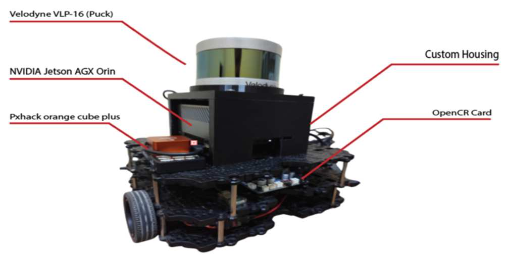
The platform is a TurtleBot Waffle Pi with a custom SolidWorks and 3D-printed housing. A Velodyne VLP-16 sits on top, with the Pixhawk Cube Orange+ IMU inside and an NVIDIA Jetson AGX Orin running ROS 2 Humble and RKO-LIO. Tests ran in basement rooms, corridors and small tunnels at Fırat University.
Accuracy on the real robot
Five indoor objects were measured with a roll meter and compared with the same lengths taken from the 3D map. The map matched within 1.47% on every object.
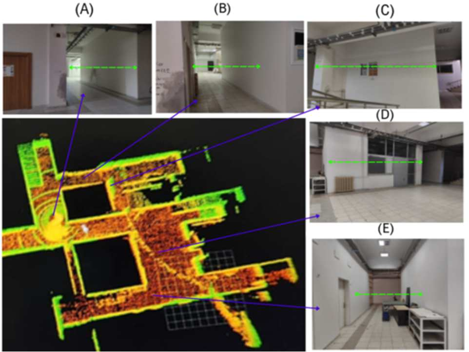
- Error: RMSE 0.026 m, MAE 0.022 m, mean error 0.69%.
- Against earlier work: a previous LIO-SAM deployment on the same sensor pair reported an RMSE of 0.355 m, so this is a 13.7 times reduction.
- Synchronisation: the corrupted maps seen with LIO-SAM because of sensor timing errors did not appear with RKO-LIO.
Simulation comparison
In Gazebo, the same recorded data from a furnished house, a warehouse and a dense bookstore was replayed offline through each method, so the sensor input was identical.
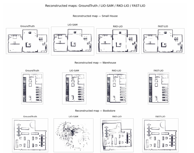
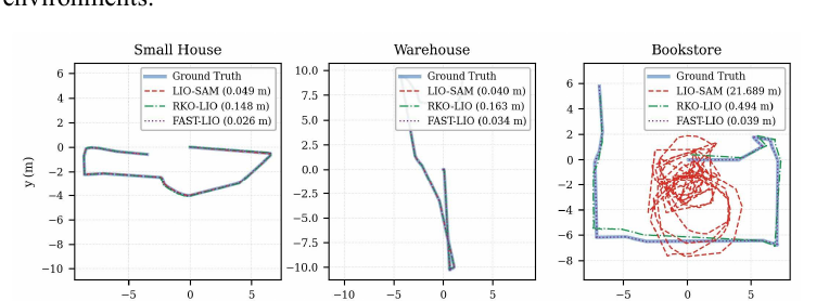
- FAST-LIO had the lowest error in every environment and is the better choice for known, feature-rich spaces with a high-rate IMU.
- LIO-SAM was accurate in easy scenes but diverged in the bookstore (APE 21.689 m) and lost the map.
- RKO-LIO was less accurate in easy scenes but stayed bounded everywhere (APE at most 0.494 m) without per-scene tuning.
Read the full paper
The complete method, tables, figures and references are in the paper. Use the Open PDF button on this page, or the IEEE record linked here.
Funded by TÜBİTAK (grant 123E406) and the Fırat University Scientific Research Projects Unit (FUBAP). Part of the study was carried out within the master's thesis of Munef El Muhammed.
Keywords