Abstract
This work presents a hardware and software integration framework for Unmanned Aerial Vehicles (UAVs) operating in GPS-denied environments. We detail the integration of a DJI Matrice M350 RTK drone with an NVIDIA Jetson Orin NX edge computing platform using Robot Operating System (ROS 2). To minimize payload cost, weight, and mechanical complexity, the system relies exclusively on a Velodyne VLP-16 LiDAR whose data is fused with telemetry from the drone's built-in high-precision Inertial Measurement Unit (IMU) nominally streaming at 200 Hz, removing the need for expensive external IMUs. We deploy RKO-LIO, a recent scan-to-map method that replaces sensor-specific noise modeling with a simplified IMU motion model and an adaptive gravity-orientation regularizer.
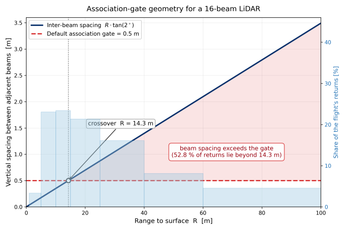
From a 458.49-meter outdoor flight reaching 38.28 m altitude we report three findings. First, the map produced onboard during flight reached an average structural error of 1.57% against laser-rangefinder measurements of six facade segments, even though latency spikes caused 41.3% of the LiDAR scans to be skipped. Second, the method's default 0.5 m association threshold is conservative for aerial operation: the inter-beam spacing of a 16-beam LiDAR exceeds it beyond 14 m range, where 52.8% of our returns lie. Relaxing it reduces the final landing-point position error, validated against a physical ground measurement, from 1.58 m to 0.31 m. Third, we characterize the timestamp fidelity of the DJI built-in IMU, delivered in bursts with 12.2% of samples arriving after gaps exceeding 15 ms.
Main contributions
- Low-cost integration: a DJI Matrice M350 RTK, a Jetson Orin NX and a Velodyne VLP-16 working together using only the drone's built-in IMU, with no external inertial unit.
- IMU characterization: a measurement of how the built-in IMU data actually reaches ROS 2 over the DJI Payload SDK.
- Aerial evaluation of RKO-LIO: a field test of the method on a drone, including how its association threshold should be tuned for a 16-beam LiDAR at altitude.
System overview
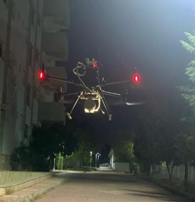
The payload mounts on the drone's E-Port, which supplies power and carries data: USB Bulk for the heavy LiDAR traffic and UART for the IMU stream and drone control. The Jetson Orin NX runs Ubuntu 22.04 and ROS 2 Humble, with a strict transform tree that places the LiDAR relative to the drone's centre of mass, where the built-in IMU sits.
Method in brief
RKO-LIO replaces sensor-specific noise modeling with a kinematic motion model and an adaptive gravity-orientation regularizer, then registers each scan against a voxel map. Points whose nearest map neighbour is farther than a fixed association gate are rejected, which removes returns from moving cars and swaying trees. For a 16-beam LiDAR the beam spacing grows with range and passes the default 0.5 m gate beyond about 14 m, so the gate becomes the key parameter at altitude.
Field test
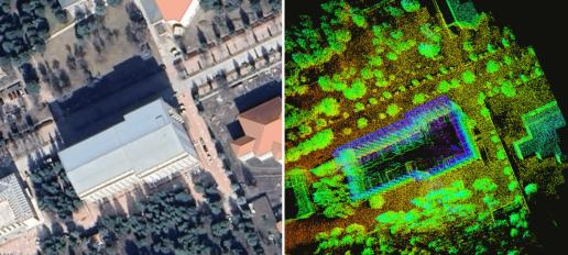
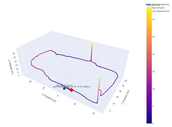
The payload was flown around a university building with trees, parked vehicles and complex facades, covering 458.49 m in about 8 minutes and reaching 38.28 m altitude. The map was built onboard during the flight.
Key findings
- Map accuracy: 1.57% average error (2.47% at most) against laser-rangefinder measurements of six building facade segments.
- Association gate: relaxing it from 0.5 m to 5.0 m cut the final landing-point error from 1.58 m to 0.31 m.
- Edge computing: the full pipeline used about 26% CPU and 2 GB of RAM on the Jetson Orin NX.
- Real-time behaviour: 41.3% of LiDAR scans were skipped onboard because of latency spikes, and 12.2% of built-in IMU samples arrived after gaps above 15 ms. The map stayed accurate regardless.
Limitations
The results come from a single flight with no continuous reference trajectory, and GNSS was available at the test site, so the approach is GPS-denied by design but was not tested under real signal loss.
Read the full paper
The complete method, tables, figures and references are in the paper. Use the Open PDF button on this page to read it.
Funded by TÜBİTAK (grant 123E406) and the Fırat University Scientific Research Projects Unit (FUBAP, grants MF.24.80 and MF.25.155).
Keywords