Abstract
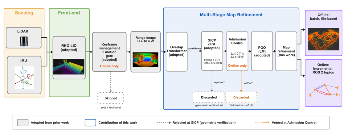
LiDAR–inertial odometry can remain locally accurate while accumulating unbounded global drift, and in structurally repetitive GPS-denied environments, the loop closures intended to remove that drift may instead corrupt the map. This paper presents MSR-SLAM, a multi-stage map-refinement framework built on an existing LiDAR–inertial odometry front-end. Loop candidates retrieved by a learned place-recognition descriptor are verified geometrically. In the offline batch configuration, geometrically verified loop constraints are incorporated into pose graph optimization after the complete sequence is available. In the online configuration, geometrically verified candidates pass through an additional admission stage that rejects constraints whose candidate-induced translational or rotational correction exceeds preset limits before they can affect the active pose graph. The global map is subsequently reconstructed from the optimized poses. The main real-robot evaluation comprised seven offline/online processing cases derived from five distinct recorded traversals in indoor, outdoor, and subterranean environments, using a Unitree Go2 quadruped carrying a 16-beam LiDAR. Additional live traversals were used separately for the online consistency analysis. In one online sequence, 14 of the 15 geometrically verified candidates were rejected at the admission stage; in a loop-free tunnel, all 310 retrieved candidates were rejected during geometric verification, and the trajectory was left unmodified. The offline failure case E4 combined excellent registration quality and large residual reduction with severe global distortion and no loop edge spanning 500 or more node indices, highlighting the need to assess loop-edge coverage alongside local fit. Three independent traversals of one environment produced geometric acceptance rates between 10.8% and 11.2%, with exactly one loop constraint admitted in each traversal. On KITTI Sequence 00, MSR-SLAM reduced the RKO-LIO ATE RMSE from 9.5525 m to 4.9322 m (48.4%) while leaving the short-term RPE essentially unchanged.
Featured application
The framework supports post-disaster and subterranean survey missions in which a legged robot must build a globally consistent three-dimensional map without satellite positioning, and in which an incorrect map correction is more damaging than an uncorrected one.
In short
A robot that maps with LiDAR slowly drifts, and loop closures are meant to fix that drift. In corridors, basements and tunnels, where places look alike, a wrong loop closure can ruin the map instead. MSR-SLAM treats the hard problem as deciding which loop closures deserve to change the map: candidates are retrieved by a learned descriptor, verified geometrically, and, when running online, a further check blocks any constraint that would force an implausibly large correction.
Main contributions
- Multi-stage framework: place recognition, geometric verification, pose graph optimization and map reconstruction, run offline in batch or online in ROS 2 with motion-gated keyframes.
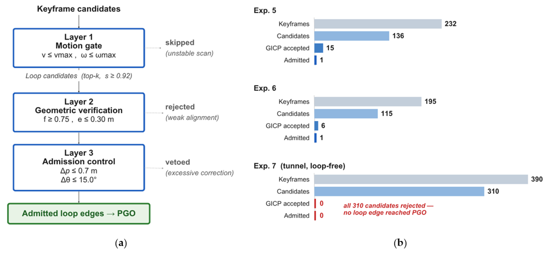
- Online admission control: each verified loop candidate is checked for the correction it would cause, and rejected above 0.7 m or 15 degrees before it can touch the active graph.
- A warning about local metrics: registration quality and residual reduction alone do not show that a refinement is correct.
- Negative-control evidence: a loop-free tunnel where nothing was admitted, and three independent traversals of one environment.
How it works
Real-robot experiments
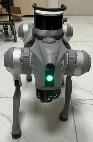
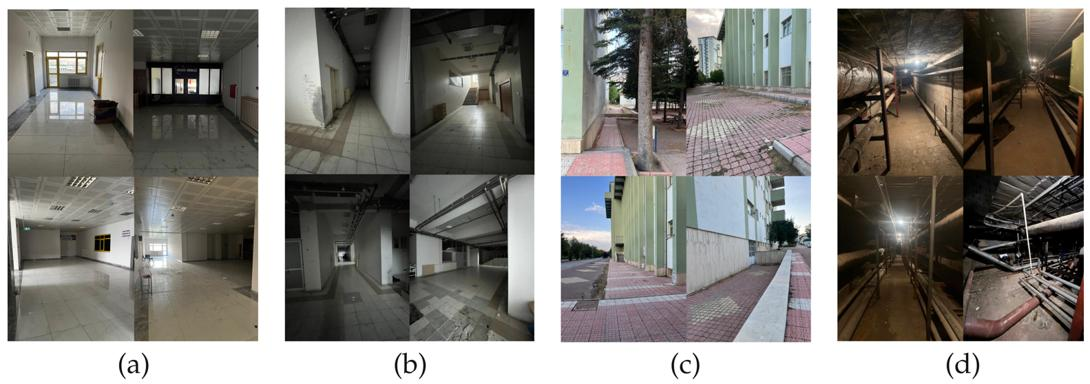
The system was tested on a Unitree Go2 quadruped carrying a 16-beam Hesai PandarXT-16 LiDAR and the robot's built-in IMU. Five recorded traversals, processed as seven offline and online cases, covered corridors, a basement, an outdoor building side and a subterranean tunnel.
Key findings
- An offline failure, reported openly: in sequence E4 the best registration scores and the largest residual reduction came with the worst global distortion, because no loop edge spanned 500 or more node indices. Local fit alone can hide a failing map.
- Admission control at work: online, 14 of 15 geometrically verified candidates in one sequence were stopped before reaching the graph. Without admission control, 14 edges were admitted instead of one and the maximum correction rose from 0.283 m to 1.235 m.
- Negative control: in a loop-free tunnel all 310 retrieved candidates were rejected by geometric verification and the trajectory was left unchanged.
- Repeatability: three independent traversals gave geometric acceptance rates of 10.8% to 11.2%, with exactly one loop constraint admitted each time.
- Physical check: four distances measured with a laser meter in one environment improved from 0.331 m to 0.031 m mean absolute error, a limited check dominated by one measurement.
Benchmark on KITTI
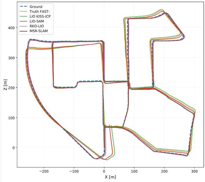
On KITTI Sequence 00, MSR-SLAM reduced the RKO-LIO absolute trajectory error from 9.5525 m to 4.9322 m (48.4%) and the SE(3)-aligned error from 3.6584 m to 1.9395 m, while the short-term relative error stayed essentially unchanged. The benefit grows with segment length, which fits a method that suppresses accumulated drift rather than changing local odometry. The baseline methods were run with loop closure disabled, so this measures the gain from adding the back-end to RKO-LIO.
Limitations
The robot experiments have no external ground truth, so absolute error is not reported. They use one platform and one LiDAR model, the place-recognition network was trained on 64-beam data, only three traversals were repeated, and the correctness of individual rejections was not independently verified.
Full paper
This paper has been accepted in Applied Sciences (MDPI) and is not yet published. The PDF and DOI will be added here once it appears online.
Funded by TÜBİTAK (grant 123E406) and the Fırat University Scientific Research Projects Unit (FÜBAP, grants MF.24.80, MF.25.154 and MF.25.155). The study was conducted as part of the master's thesis of Munef El Muhammed.
Keywords